technology
Ancient geology, Antarctic ice sheet, Antarctic snow sheet, Antarctica, Antarctica new map, Bedmap3, bizarre news, British antarctic survey, Climate Change, ghostly news, Glaciology, hatke news, Hidden landscape, Ice thickness, Omg news, Radar mapping, Sea Level Rise, Snow thickness survey, Strange news, Uneartly story, Weird News
mohitmittal55555@gmail.com
0 Comments
British Antarctic survey prepared a detailed map of Antarctica


Contents
Last updated:
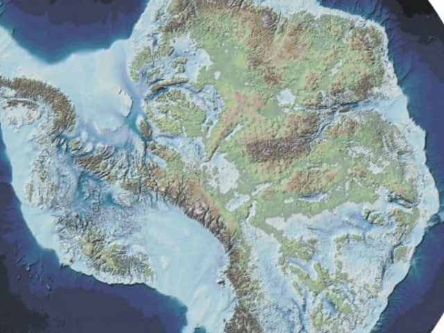
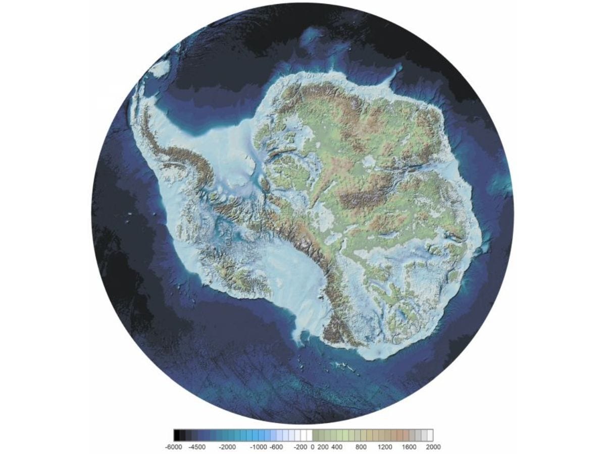
Scientists showed a glimpse of the new map of Antarctica ‘Bedmap3’ hiding under snow in the British Antarctic survey. If the ice of the earth’s icy desert Antarctica melts, then it gives mountains, rivers and deep pits …Read more

This map has been released by the British Antarctic Survey.
Antarctica, which today is a cold and deserted continent covered with snow, was once green and full of life. It is difficult to believe, but the secret of that ancient terrain is hidden under a sheet of thousands of meters thick, which no person has seen till date. The British Antarctic survey has tried to highlight this mystery for the past several decades. Through radar, sound waves and gravity mapping, he has prepared the most detailed map of the terrain hidden under ice, named Bedmap3. This map not only shows ancient mountains, rivers and plains, but will also help scientists in understanding the impact of climate change.
The team of the British Antarctic Survey was led by glacieologist Hamish Prichaard. He said that this map is very important to understand the complex relationship between snow and land. Says PriChard, “By putting a syrup on a cake, the emergence of his surface and the direction of the flowing of the syrup, the same under the ice in Antarctica decide where the snow will flow faster.” Bedmap3 contains 8.2 million data points from 277 snow thickness surveys, which meet the shortcomings of previous maps. This map showed that the thick ice in Antarctica is 76.052 degrees south and 118.378 degrees east, where the thickness of ice in an anonymous valley is 4,757 meters (15,607 ft). Earlier this place was considered in the astrologers of Edelie Land. The map also cleaned areas such as the southern pole, the coast line of the Antarctic Peninsula, the Western Antarctica and the Transantarctic mountains.

This is a detailed map.
Antarctica has a total of 27.17 million cubic kilometers of snow, which covers an area of 13.63 square kilometers. The average thickness of ice, including the shelf, is 1,948 meters and 2,148 meters except the shelf. If all this ice melts, the sea level can rise up to 58 meters. Cartographer Peter Freightwell says, “We now came to know that the Antarctic snow sheet is thick from the first thinking and more ice is frozen on the rocks below the sea level. It increases the risk of melting with the increasing effect of hot seawater.” Explain that this map is the result of data collected from planes, satellites, ships and sleda teams of dogs. This not only shows the ancient geography of Antarctica, but also states how weak this continent can be due to climate change. Scientists believe that this information will help in predicting future snow flows and sea level changes. This research has been published in scientific data.
Share this content:


Post Comment Cancel reply